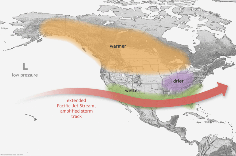
The everyday 3:00pm thunderstorm that South Florida residents are all too familiar with is one of the most characteristic weather patterns of the state. But there may be a hidden driver causing chaotic and heavy rainfall this fall season. El Niño, the warm phase of the El Niño Southern Oscillation, is a natural climate pattern that begins in the tropical Pacific Ocean. During an El Niño event, surface waters in the central and eastern tropical Pacific become warmer than average, changing atmospheric circulation and shifting the position of the jet stream. Those changes can influence weather patterns far beyond the Pacific, including right here in Florida.
According to the National Oceanic and Atmospheric Administration (NOAA), El Niño conditions are currently present and strengthening. As of September 2026, NOAA is forecasting a greater than 90% chance that a very strong El Niño will occur during the fall and winter of 2026 and 2027. One of the biggest changes Florida can expect is more rain during the cooler months. Florida is no stranger to rain, but El Niño can shift our usual weather patterns. Historically, El Niño has been associated with wetter-than-average conditions across Florida and the Southeast, particularly during the fall, winter, and early spring. The stronger the El Niño, the more consistent this pattern tends to be. NOAA's current seasonal outlook is already favoring above-normal precipitation across much of the Southeast, with some of the highest probabilities extending into northern Florida andthe Gulf Coast. For Florida, that could mean more rainy days, wetter soils, fuller wetlands and waterways, and an increased risk of flooding in some areas.
Despite a significant increase in rainfall and flooding conditions during an El Niño, the weather phenomenon can actually make hurricanes in the Atlantic ocean less likely to develop and strengthen. El Niño typically increases vertical wind shear over the Atlantic ocean which can disrupt developing tropical systems, making it more difficult for thunderstorms to organize into hurricanes. In fact, NOAA's 2026 hurricane season outlook identified the developing El Niño as one of the factors favoring a below-average Atlantic hurricane season. This strong climate driver may also lead to cooler-than-average conditions during parts of the winter in Florida. The stronger subtropical jet stream associated with El Niño can help push storm systems across the southern United States. For Florida and the Southeast, this often means increased cloud cover, rainfall, and storminess, which can contribute to cooler winter temperatures.El Niño serves as a reminder that even something happening thousands of miles away in the Pacific Ocean can ripple through ecosystems right here in South Florida.
Remember to keep your rain boots handy this winter!
https://www.noaa.gov/understanding-el-nino